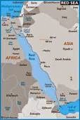
Africa, the second largest
continent on Earth, is connected to Asia
through the isthmus of Suez. Both the
highest and lowest points are located in the eastern half: Mt.
Kibo, a peak in Tanzania at
19,340 feet is the highest, and the Qattarah Depression in Egypt, at 436
feet below sea level, is the lowest point.
The most spectacular feature of the continent, however, is the Great Rift Valley.

In Asia, the historic region of Palestine, on the Levant shore of the eastern Mediterranean, is the northern anchor of the Rift Valley. Al Biqa is an upland valley in Lebanon, between the Lebanon and anti-Lebanon mountain ranges, drained by two rivers: the Orontes, flowing north into Syria and the Litani flowing south through Lebanon where it empties into the Mediterranean Sea north of Tyre. It is the northern end of the Rift Valley, which then continues through the valley of the Jordan River. The headwaters of the Jordan River converge in northern Israel and flow south between Israel and the Golan Heights and through the Sea of Galilee (Lake Tiberias) into a below-sea-level valley called the Ghor, where it forms the boundary between Israel and the West Bank on the west, and Jordan on the east, before emptying into the Dead Sea, a salt lake in the arid Jordan trough of the Rift Valley on the Israel-Jordan border. It is 1,292 feet below sea level, the lowest point on earth.
The Rift Valley returns to land at Danakil, a desert region in northeast Ethiopia and northern Djibouti, adjacent to the Bab el Mandeb, and continues southwest into Ethiopia, from the direction of Djibouti, toward a string of lakes starting southeast of Addis Ababa and running southwest. The series of lakes include an unnamed lake followed by Lakes Ziway, Langano, Abiyata and Shala. Then there is a small lake near Awasi, with Lakes Abaya and Ch’amo following, ending at the Ethiopia / Kenya border, with Lake Ch’ew Bahir. The Rift Valley continues in northeast Kenya with Lake Turkana and then separates into the East Rift and the West Rift.

The West Rift Valley continues from Lake
Turkana, west of Lake Victoria to
Lakes Albert and Edward on the Uganda
/ Zaire
border, south to Lake Kivu on the Zaire/Rwanda border. Lake Kivu
has the distinction of being Africa’s highest
lake at 4,790 feet. From Lake Kivu the rift goes through Lake
Tanganyika to Lake Malawi
(Nyasa). Lake Tanganyika is a large
freshwater lake, considered the second deepest lake in the world, having a maximum
depth of
 ~ 4,700 feet. Lake
Malawi is also a large freshwater lake, but bounded by steep mountains. It is drained by the Shire River
into the Zambezi River and empties into the Indian Ocean through Mozambique.~ 4,700 feet. Lake
Malawi is also a large freshwater lake, but bounded by steep mountains. It is drained by the Shire River
into the Zambezi River and empties into the Indian Ocean through Mozambique. At Lake Malawi,
the eastern and western arms of the Great Rift Valley
join and end in Mozambique,
the southern anchor.
~ 4,700 feet. Lake
Malawi is also a large freshwater lake, but bounded by steep mountains. It is drained by the Shire River
into the Zambezi River and empties into the Indian Ocean through Mozambique.~ 4,700 feet. Lake
Malawi is also a large freshwater lake, but bounded by steep mountains. It is drained by the Shire River
into the Zambezi River and empties into the Indian Ocean through Mozambique. At Lake Malawi,
the eastern and western arms of the Great Rift Valley
join and end in Mozambique,
the southern anchor.
THE PROBLEM
~ 4,700 feet. Lake
Malawi is also a large freshwater lake, but bounded by steep mountains. It is drained by the Shire River
into the Zambezi River and empties into the Indian Ocean through Mozambique.~ 4,700 feet. Lake
Malawi is also a large freshwater lake, but bounded by steep mountains. It is drained by the Shire River
into the Zambezi River and empties into the Indian Ocean through Mozambique. At Lake Malawi,
the eastern and western arms of the Great Rift Valley
join and end in Mozambique,
the southern anchor. THE PROBLEM
During the last 10-15 years, and possibly longer, studies of the Rift Valley in the Kenya / Tanzania regions have determined that an increasing flow of water, probably from an aquifer, deep well, underground river or other such water source, has been infiltrating parts of the Rift Valley in Africa. While the local and short-term irrigation benefits of such flows are obvious, there is some concern of the long-term effects.

Other considerations:
The rift is replete with faults and the area within the arc has suffered
environmental stress due to deforestation and human-induced desertification.
POTENTIAL
RISKS
The infiltration of water, while not an immediate problem,
could in geological time cause major problems to the land mass within the arc:
- By the formation of a number of additional lakes which will in time (geological time) join to form an inland sea;
- By lubricating the faults, permitting them to temporarily relieve built-up stresses, but in the long-term cause more severe earthquakes when they do occur;
- By adding substantial weight to the fault areas and causing the land mass included in the arc to partially or completely breakaway from the African continent. This may occur in any one or more of three areas:
Area 1. Djibouti through the “funnel” to Lake
Turkana, to the rift east arm, to the Olduvai Gorge, to a point on the coast of Tanzania near Dar es Salaam,
including the horn of Africa, all of Somalia, and
major parts of Djibouti,
Ethiopia,
Kenya and
Tanzania;
Area 2. Lake Turkana to the rift east arm, to the Olduvai Gorge, to a point on the coast of Tanzania near Dar es Salaam, south to the mouth of the Zambezi River, to Lakes Malawi Malawi and Tanganyika, to the rift west arm, to Lake Turkana, including all of Uganda, Rwanda and Burundi, and major parts of Kenya, Tanzania, and Mozambique; or
Area 3 All of Areas 1 and 2 from Djibouti to the mouth of the Zambezi River.
POSSIBLE
SOLUTIONS
Despite the obvious dangers and the current risks, no
solutions have been or are proposed. In
fact, few scientists or politicians are willing to
acknowledge that problems exist and are willing to let nature take its
destructive course, evidenced by the recent prolonged killer floods.
2001
LFC
LFC
No comments:
Post a Comment